Wednesday, October 14, 2020

C.A. "Peter" Newham and the Station Stone Rectangle

There's an excellent little book by C.A. "Peter" Newham called "The Astronomical Significance of Stonehenge" (originally published in 1972) in which he lays out his ideas about the monument, and specifically a new thought about the possible Lunar significance of the Station Stone Rectangle.

What's not as readily available is the first publication of his ideas, which occurred in an article written by Science Correspondent Douglas Emmott in The Yorkshire Post on Saturday March 16th 1963.

The article is entitled "The Mystery of Hole G", and I've been trying to find a copy of it for years without success. Until today, when the local and family history librarian at Leeds Central Library, Helen Skilbeck, kindly sent me a scanned copy from their archives of The Yorkshire Post.

I've reproduced the text of the article here for posterity.

The Mystery of Stone G

========= BY DOUGLAS EMMOTT =========

Attention this week has once again been focused on Stonehenge, where one of the uprights was blown down in a gale.

In this article, The Yorkshire Post Science Correspondent discusses an amateur astronomer's intriguing theories which may add a new chapter to the story of Stonehenge.


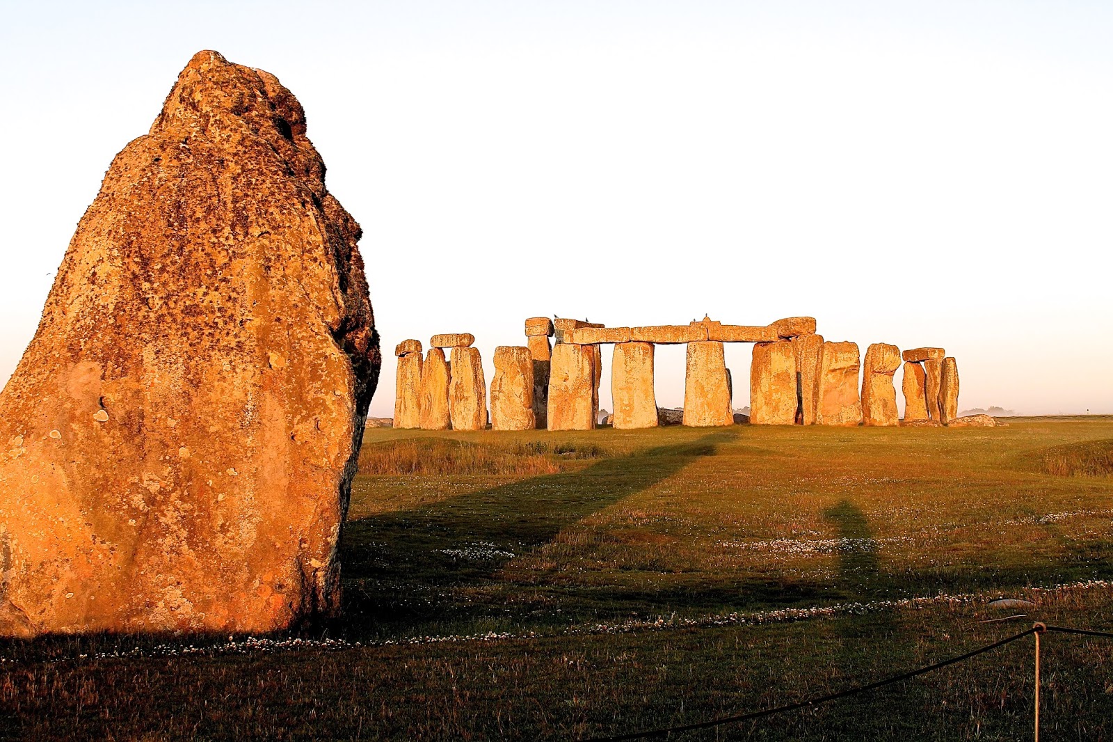
STONEHENGE, that mysterious monument which rises above Salisbury Plain, may be a little less inscrutable than had been supposed.

An amateur astronomer, Mr. Peter Newham, 63, of Tadcaster, has formulated an intriguing hypothesis which, if proven, might open up whole new fields of inquiry in a subject which has yielded very little significant new information since the last major excavation nearly 40 years ago.

If Mr. Newham's line of reasoning is sound, the positions of certain hitherto inexplicable features of Stonehenge would be explained.

For the purposes of this inquiry the plan of Stonehenge given here is reduced to the elements bearing upon the new theory.


In 1846, the Rev. E. Duke discovered that the North mound 94 lined up with a stone numbered 93 at the last light of the setting sun on the shortest day of the year. Conversely, a line drawn from the South mount (92) to stone 91 aligned with the rising sun on the longest day of the year.

It was discovered, too, that the axis of the Sarsen stone circle was similarly aligned. In fact, the positions of sunrise and sunset are slightly different today owing to the progressive shift of the earth's axis.

So much, then, is established. What follows is speculation. On several occasions in the past few years Mr. Newham has visited the site and made careful observations of his own.

The first remarkable discovery he made was that a line drawn from mound 94 to 91 would appear to coincide with the point on the horizon where the moon rises at its most southerly point during its 19-year cycle.

Conversely, the line from 92 to 93 marks the moonset at its most Northerly setting point. The suggestion that these two alignments are of significance is bolstered by the curious fact that the main Sarsen circle of stones is about a yard off-centre with the outer Aubrey circle of burial holes.

Had it been quite concentric, the 92-93 sighting would have been obscured. Is this the reason for the off-centredness which has puzzled generations of archaeologists?

It must be remembered that the layout of Stonehenge has been drawn up generally with remarkable precision. The ancient architects were evidently knowledgeable geometricians: indeed, the feat of measurement would tax a modern surveyor with the most up-to-date instruments and techniques.

Unusual feature

From this point, attention is turned to another unusual feature. This is catalogued as "hole" G, the middle of three equally spaced "holes" lying to the East and just beyond the Aubrey circle, and for which there is no convincing explanation.

Most Stonehenge authorities have dismissed these disturbances as natural or "shrub-holes." Their disconcerting symmetry and the absence of similar features within the whole of the area that has been uncovered have prompted doubts in more cautious minds.

Mr. Newham has noted that a line drawn from 94 to G appears to mark the rising sun on the shortest day of the year. Mound 92 to G marks the moonrise at its most Northerly point.

Thus, six of the eight major solar/lunar events of the year are apparently accounted for within the theory. To complete the octet, Mr. Newham has postulated the existence of a further marker hole in the unexcavated part of the site about 16 yards South of 93. This he has provisionally designated G2.

Now, a line drawn from 92 to G2 would mark the setting sun on the longest day, while 94 to G2 would mark the moon set on its most Southerly point. Thus, the hypothesis has the added merit of inviting confirmation. If the hypothetical G2 should, in fact, be discovered the possibility of coincidence could be virtually eliminated. The key which now seems to fit the lock would surely turn.

Advanced culture

It would seem, therefore, that Stonehenge might be a far more comprehensive calendar in stone than has been supposed. This, in turn, would suggest that the builders of the later portions of the monument were of a more advanced culture than the native inhabitants of Britain at that time says Mr. Newham. There is supporting archaeological evidence for this view.

A few years ago, there would have been no difficulty in obtaining permission to search for positive confirmation of the existence of G2. One would simply have dug about the point indicated and sought the necessary proof.

Today, however, archaeologists tread with infinite care. In the past, crude pickaxe excavating has destroyed a wealth of detailed information which modern science would have been capable of deciphering. Such brutal methods have wrought such havoc with the "shrub-holes," for example, that it is now almost impossible to determine their real significance even with advanced techniques.

Reluctant to dig

Conscious of this fact and realising that future generations of investigators will read much greater meaning into undisturbed evidence than we might hope to do, the custodians of Stonehenge are reluctant to dig. Nearly one half of the site remains virtually unexplored below ground and only in exceptional circumstances will the Ministry of Works sanction further excavation.

It is conceivable, however, that archaeological advisers will recommend a search for Mr. Newham's ghost-hole, G2 by preliminary above-ground detection methods. Encouraging soundings would indicate a call for spade and trowel - and, perhaps, the opening of a new chapter in the story of Stonehenge.

==========


Friday, July 24, 2020

Avenue Walk and the Durrington Walls Pits

In mid 2020, the Stonehenge Hidden Landscapes Project published findings from their extensive geophysics work in the World Heritage Site in which they revealed the discovery of "A Massive, Late Neolithic Pit Structure associated with Durrington Walls Henge" (https://doi.org/10.11141/ia.55.4).

This is a roughly circular arrangement of 10m wide by 5m (at least) deep pits centred on Durrington Walls with an overall diameter in excess of 2km - a truly enormous landscape feature.

The discovery has already prompted a remarkable event - the deferring of the decision by the UK Government's Transport Secretary, Grant Shapps MP, on whether to build the Stonehenge Tunnel. As this BBC News Story highlights, such a major find within the Stonehenge World Heritage site, very close to the proposed location of the Tunnel's Eastern Portal entrance, means that "further consultation" is required.

The decision has been put back until November 2020 to allow time for an analysis of the significance of this completely unexpected archaeological result.

LIDAR of Durrington Walls overlaid with the pit circle locations
I found myself wondering whether there was any significance to the arrangement and positioning of these "pits", but couldn't see anything obvious from the plan.

Then I decided to stop looking at the plan, and instead look at the landscape from ground level.

I georeferenced the pit locations into Google Earth, stuck markers in them, and took a virtual stroll along the course of the Stonehenge Avenue from West Amesbury Henge (aka Bluestonehenge) at the River Avon towards Stonehenge.

What I saw astonished me.

The pit locations occupy positions that serve to frame the eastern horizon from Larkhill Causewayed Enclosure via Sidbury Hill to the northern ridge running from Beacon Hill.

Each of these horizon features was important in the Neolilthic.

Larkhill Causewayed Enclosure 

Larkhill's enclosure pre-dated the Durrington Walls pits by almost 1000 years yet it is included in their circuit. Later Beaker period inhumations at the entrance, together with a pit alignment pointing off towards Barrow Clump and Sidbury Hill suggest strongly that this site retained its significance for generations.

https://www.archaeology.co.uk/articles/larkhill-causewayed-enclosure.htm
https://www.wessexarch.co.uk/our-work/larkhill
https://intarch.ac.uk/journal/issue47/7/5-6.html

From the Intarch article above:
"Monuments may have formalised or commemorated movements and gatherings of different scale, though the emphasis on localised patterns of visual perception perhaps relates to movements around the landscape at a community scale."

Sidbury Hill

Sidbury Hill lies exactly on the Stonehenge summer solstice alignment from the stone circle, and appears to have been important as a source of a particular kind of flint associated with dozens of neolithic pits and a flint working industry discovered during the Army Rebasing Housing Development at Bulford.

Those pits contained an odd assortment of apparently deliberately deposited artifacts, and next to them was a peculiar "double henge". Opposite the housing development is the Bulford Stone - a natural sarsen boulder which was erected next to where it originally formed on top of the chalk, and next to it is a prehistoric grave which contains significant and unique grave goods.

Phil Harding (recognised as the leading expert on prehistoric flint working) regards the Bulford pits and double henge discovery as one of the most significant for decades. Sidbury Hill seems to have been of pre-eminent importance and focus to these neolithic people, and also to those who came later because three long Bronze Age linear ditches converge at Sidbury Hill - one from the west, one from the north and one from the east.

https://modmedia.blog.gov.uk/2016/04/15/bulford-dig-unearths-archaeological-treasure-trove/
https://www.wessexarch.co.uk/our-work/bulford
 

Beacon Hill Ridgeline

The ridge leading to Beacon Hill has been cited as a possible target for the alignment of the Stonehenge Greater Cursus. Although this earthwork monument runs roughly west-east, it is not accurately aligned on the equinox sunrise and set. Instead, it seems to be drawing attention to the eastern horizon, particularly the area immediately north of the summit of Beacon Hill.

In alignment with and east of the Cursus, between the Cursus and the River Avon, lies the Cuckoo Stone near to Durrington Walls itself. This stone is another natural sarsen boulder which was erected next to where it formed. It seems to have retained its importance down to Romano-British times as the discovery of the square Roman "wayside temple" right next to it indicates.

https://www.researchgate.net/publication/228804259_The_Stonehenge_Riverside_Project_exploring_the_Neolithic_landscape_of_Stonehenge

The Avenue Walk

Larkhill enclosure, Sidbury Hill and the Beacon Hill ridge are the primary features of the horizon that are framed by the Durrington Walls pit locations as you walk along the Avenue.

At every point along this route, the arrangement of pits neatly brackets this section of the horizon - the arrangement of pits in a circle neatly counteracts the parallax effect that an otherwise straight-line arrangement would suffer.

Once you reach King Barrow Ridge and Stonehenge comes into view, the eastern horizon frame fades away as you descend into Stonehenge Bottom and begin your final approach to Stonehenge itself.

Now that you have the background, have a look at the video I've created that shows the effect.

This video (which has no audio, by the way) makes use of Google Earth, into which I have georeferenced the locations of the Durrington Walls pits from the Stonehenge Hidden Landscapes Project's recently published paper about their discovery. The line of the Avenue itself is taken directly from the Stonehenge Riverside Project's "Seeing Beneath Stonehenge" Google Earth dataset. Markers for Sidbury Hill and Larkhill Causewayed Enclosure were added by me.

It's best viewed full screen on YouTube (https://youtu.be/P-XvMyBrTxY), but here's an embedded version. (Update: I've added a commentary in the subtitles, so remember to switch them on before viewing)


Is it possible that the entire landscape is repeatedly and deliberately being memorialised by generations of ancient people through the careful framing of and drawing of attention to elements of their world that have achieved "specialness" through aeons of time?

I think so.

This, if true, indicates an outstanding aesthetic sense and a desire to undertake "landscape engineering" on an absolutely epic scale. It shows an interconnectedness not only in space but also through immense spans of time, reinforcing a people's relationship with the land and their past.

What I find most interesting is that the route of the Avenue has been a subject of controversy for a long time. It's not the easiest stone-transport route from the Avon to Stonehenge, but seems instead to have been designed (at the depths of the valley at Stonehenge Bottom) to induce a sense of expectation prior to the final approach along the solstice axis to Stonehenge. Indeed, at that final turn (the "Elbow"), Stonehenge disappears from view entirely, only re-emerging as you climb the slope towards the setting winter sun.

The part of the Avenue route leading from the Avon to King Barrow Ridge now seems to me to have its own crucial significance - keeping in clear view all the parts of the eastern horizon that have a meaning to those undertaking the journey.

Perhaps, given the idea that the Avenue was part of a ritualised journey from life to death from Durrington Walls to Stonehenge, this sharp focus on a particular sweep of the eastern horizon serves as an act of rememberance of all those who have gone before.

And those pits don't even have to be visible for that to happen - just an understanding that they are there and that they are positioned to induce this feeling would be enough.

What a majestic achievement, still appreciable across open farmland nearly 5000 years after it was laid out.

Pity it might all be spoiled by driving a 4 lane expressway directly through the critical part of the view.

Update: 11th August 2020 

Professor Vince Gaffney has kindly given me permission to include an animation that was generated using the software that accompanied the 2000 Archaeopress publication "Stonehenge Landscapes: Journeys Through Real-And-Imagined Worlds" (Exon S, Gaffney V, Woodward A and Yorston R).

 It shows the viewsheds and monument visibility that develop from the point of view of someone walking the line of the Avenue from the River Avon to just beyond King Barrow Ridge.

 (Credit: R. Yorston. Major monument animation from Exon et al. 2000. Stonehenge Landscapes)

Monday, June 22, 2020

The Shadow of the Heelstone

The most commonly known thing about Stonehenge is that it lines up with the Summer Solstice sunrise and Winter Solstice sunset.

In summer, celebrants gather in their tens of thousands to spend the night in and around the stone circle hoping to see the Sun rise over the Heelstone.

But it may be that everyone is facing the wrong way by looking at the Sun and they ought to be facing the other way and watching a shadow play instead.

In the early 1990s, Professor Terence Meaden rediscovered an almost totally forgotten aspect of the monument and published his findings in a book called "The Stonehenge Solution" (Souvenir Press, 1992).

He said that the Heelstone cast a shadow at dawn on the summer solstice which penetrated into the stone circle and reached the Altar Stone. This, he wrote, represented a sacred marriage or "hieros gamos" of the Sun and the Earth. The Sun God at the height of his power was fertilising the Earth Goddess by means of the Heelstone shadow - the Earth Goddess being represented by the stone circle and its central horseshoe of trilithons.

An intriguing idea, and not without precedent in societies where human participants take part in and facilitate such ceremonials both in ancient and modern times.

Is it a coincidence that 9 months after summer solstice comes the vernal equinox, when the Earth erupts into vibrant life once more?

In 2013 I was able to capture an image of the Heelstone's shadow shortly after dawn on the 24th June.

05:14 BST, 24th June 2013
There are a couple of obvious problems with this photo - and it's not the people enjoying a ceremony in the centre.

The first is that it's a few days after summer solstice (21st June usually, 20th in leap years). This shouldn't be too much of an issue because the Sun's rising (and setting) position on the horizon stays almost exactly the same for a few days either side of solstice (it's what solstice means - "Sun stands still").

The second problem is more serious - the shadow is off to the right of the main entranceway into the stone circle, and as the Sun rises higher the shadow moves further to the right and grows shorter. Does this mean I should have taken the photo earlier, or that the whole concept is flawed?

Two major things have changed in the landscape since Stonehenge's large sarsen stones were put up 4,500 years ago.

One is that the horizon to the northeast in Larkhill is now cluttered up by a modern collection of trees exactly where the Sun rises at solstice. This delays the appearance of the Sun by almost 10 minutes, by which time it has moved upwards and eastwards.

The other is that the Earth's axis of rotation has changed its tilt a little. When Stonehenge was built, it was at 24° and now it is 23.5°. This slight reduction has caused the summer solstice sunrise position over an ideal horizon to move to the right (eastwards), by about 1°.

The combination of these factors mean that where once the Sun rose to the left of the tip of the Heelstone over a clear horizon, it now rises out of the tip and through trees - which is why the Heelstone's shadow doesn't seem to fall through the entranceway any more.

I can't do anything about the Earth's tilt, and although I'm trying it's not easy to persuade the military to expend resources felling trees on their estate to clear up the Larkhill sightline.

What I can do is to try and take photos closer to the actual solstice day than the 24th June, to see if the shadowplay improves at all. A clear-to-the-horizon sky within a day either side of summer solstice is rarer than you might think. The few occasions I've seen one have mostly coincided with the actual solstice day, when upwards of 10,000 people are standing exactly where the shadow should fall.

June 2020, however, has been different. The Covid-19 lockdown has meant Stonehenge has been entirely off-limits to early morning inner-circle visits (so no ceremonies), and the usual Open Access at summer solstice was cancelled with a security presence on site to discourage anyone attempting a large gathering.

This morning, the 22nd June, was happily clear of clouds and people and so I walked to Stonehenge to attempt to photograph the Heelstone shadow.

A mist lay in the Avenue field but not the rolling fog that so often billows around the monument when everywhere else is clear.

At 05:02:17 BST, the first gleam of the Sun appeared through the treetops at Larkhill.

First gleam at 05:02:17 BST - a tiny pinprick of light through the treetops of Larkhill

11 seconds later the upper limb of the Sun emerged.

Upper limb appearance at 05:02:28 BST

The timelapse of 100+ photos taken over the next 15 minutes revealed some useful information.

Although it is practically impossible to see without processing the image to stretch the contrast, the Heelstone shadow is present in this photo. It's not visible on the ground, but on the lower left side of the face of Stone 30 - the stone on the right hand side of the entranceway into the stone circle.

First sight of the Heelstone shadow - yes, I know you can't make it out in this unprocessed image!
This next image has been very heavily processed - I have massively increased the saturation to highlight the difference between the reddish-pink stones glowing in the light of the rising Sun and the more neutral gray colour where the shadow lies. This is not simply an area of the stone that's not facing the Sun (because it is facing the Sun), as you'll see later.

The lower left corner of Stone 30 is in shadow - the Heelstone's shadow
As time went on, minute by minute the shadow became more distinct. By 05:09:17 it was obvious, both on the face of Stone 30 and also on the grass.

The Heelstone's shadow is now visible on the grass, and the tip of the shadow on Stone 30 has moved to the right
At 05:14:10 we're at practically the same moment as my 2013 photo, and the Heelstone shadow is just about to leave the base of Stone 30.

The same clock time as in 2013, but two calendar days earlier (22nd rather than 24th June)
The caption above says "two calendar days earlier" - in fact it's one actual day earlier because this year is a leap year and 2013 wasn't. Today would be the 23rd June if 2020 wasn't a leap year. It's matters like this that archaeoastronomers lose sleep over.

I stopped taking photos from this position at 05:16:55 as by then the shadow had moved off the stones entirely, and I had what I needed.

05:16:55 BST
What does all this prove?

The key thing is that the tip of the Heelstone shadow is at least 1m above ground level when first seen on the face of Stone 30.

This means that the shadow definitely penetrates into the stone circle and must reach the Altar Stone. This is a secondary confirmation since if you lie down inside the circle with your head on the Altar Stone looking towards the Heelstone you can see that the Heelstone tip is above the horizon line (the tree-lined one, and therefore also the actual horizon).

4,500 years ago, without trees and with the Earth's axis at 24°, the Sun would be fully risen by the time the tip of the Heelstone shadow coincided with the primary axis of the monument and so a strong and clear shadow would be visible running from the Heelstone up to and into the circle.

Terence Meaden's work is confirmed.

I'm very glad to have been able to help cross-check this shadow play phenomenon, and Terence has now got copies of all the photos I took this morning so he can do his own processing on them. His recent work on the stone circles of Ireland shows that similar shadow play is evident there too (see "Stonehenge, Avebury and Drombeg Stone Circles Deciphered" for more details), and he's moving on to investigate the Cornish ones.

It's beginning to look a lot like the builders of these monuments encapsulated the movements of the Sun with an incredible subtlety that we are only now starting to appreciate.

My time-lapse movie (together with explanatory notes) is available on YouTube at https://www.youtube.com/watch?v=U_4iPMdjnGs, and I've also embedded it below for your convenience.


I hope you've enjoyed this excursion into experimental archaeoastronomy.

Additional note: when researching a topic related to the traditions associated with Stonehenge, I happened across a passage in Gerald Gardner's 1959 book "The Meaning of Witchcraft" (Aquarian Books, 1959, p40) which reads:
“At any rate, according to the witch beliefs the inner “horseshoe” of stones at Stonehenge represents the womb, and what should be watched for at sunrise at the Summer Solstice, the longest day, is the shadow of the Hele Stone which enters this “womb” as the sun rises and fecundates it for the coming year.”

Consulting with Terence, he was unaware of this earlier reference and so it seems that some otherwise "lost" knowledge of Stonehenge has been preserved amongst the followers of the Old Ways. I'm not at all surprised.